Aerial Survey, Imaging, and Cinematography Services in Tampa
Florida Aerial Observation Solutions
Tampa Helicopter Charters facilitates comprehensive aerial survey operations across Florida, leveraging the unique low-altitude and hover capabilities inherent to helicopters. Our services encompass a broad spectrum of methodologies, including magnetometer and electromagnetic surveys, LiDAR data acquisition, and precise GIS mapping, tailored to meet specific project demands. Furthermore, we specialize in advanced aerial cinematography and photography services, offering access to specialized equipment for high-definition visual capture. Options range from aircraft configured for handheld photographic operations, involving door removal for unobstructed views, to platforms compatible with sophisticated gyro-stabilized camera systems. We provide a robust suite of aerial imaging solutions for detailed data collection and visual media production throughout the Tampa Bay area and statewide.

Aerial
Surveys
LiDAR, GIS Maps, FLIR, HD Video & More
Tampa Helicopter Charters delivers essential aerial support for critical infrastructure management. Our capabilities extend from comprehensive pipeline surveys and Rights-of-Way (ROW) inspections to meticulous transmission line patrols. We ensure access to the appropriate aircraft, specialized sensor equipment, and experienced personnel necessary to execute your project with precision and operational efficiency across Florida.
High Tech Results
The Top Pilots in Florida, Today's Technology... Maximum Results.
Call 813-438-6626 Now!
Tampa Helicopter Charters provides the tools needed to complete your land surveys, utilizing the right equipment to provide the aerial photos that are often needed.
Precision aerial surveys streamline complex tasks such as Rights-of-Way (ROW) and site inspections, the acquisition of topographical data, and high-definition photographic documentation for commercial development projects. Helicopters are uniquely suited for inspecting Florida's diverse landscape, offering unparalleled vantage points for pipeline integrity assessments, identifying anomalies in transmission lines, and detailed property imaging. Tampa Helicopter Charters specializes in developing bespoke photographic and remote sensing operations. These solutions are meticulously engineered for each client, optimizing technical performance, financial efficiency, and ensuring superior data acquisition and actionable results for your projects within the Tampa Bay area and statewide.
Helicopters offer distinct operational advantages for aerial surveying, capable of significantly lower and slower flight profiles compared to fixed-wing aircraft. While Federal Aviation Administration (FAA) regulations mandate fixed-wing aircraft maintain a minimum altitude of 1,000 feet above the highest obstacle, helicopters can operate at considerably reduced altitudes. This capability, coupled with their ability to hover, makes them the optimal platform for detailed inspection of challenging or hazardous zones. Such operational flexibility provides engineers and project managers with critically precise perspectives and data acquisition opportunities that are otherwise unattainable by conventional aerial platforms across Florida.
There is no better way to conduct your visual survey, animal population counts, soil drainage analysis, ROW inspections, pipeline and transmission line inspections, and geographical surveys.
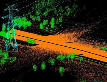
LiDAR Imaging
Light Detection and Ranging, or LiDAR, is a remote sensing method used to examine and measure Florida topography as well as objects, like vegetation, upon it.

Infrared Imaging
Thermographic IR cameras are used to detect radiation in the long-infrared range of the electromagnetic spectrum and produce images of that radiation, called thermograms.

HD Video Gimbal Capture
Modern HD and 4K cameras can be mounted to helicopters, using the proper STCs, with a gimbal to stabilize photos & videos for detailed results.

Precision Aerial Cinematography and Visual Media Solutions
For expert camera work in the Tampa Sky
Get a Fast, free QuoteTampa Aerial Cinematography
Tampa Helicopter Charters provides comprehensive access to advanced resources for professional-grade aerial cinematography across Florida. Our network facilitates custom aerial shoots by offering state-of-the-art gyro-stabilized camera mounts, including systems such as Tyler Mounts, Wescam, Cineflex, Pictorvision, and SpaceCam. These platforms are compatible with high-performance specialty cameras, including Cineflex HD, RED Epic, Arri Alexa, alongside cutting-edge 3D and experimental camera systems. We support diverse production requirements, from precise air-to-air tracking shots to dynamic ground-to-air perspectives, ensuring all facets of your production goals are met. Our network’s experienced flight crews collaborate closely with your aerial Directors of Photography and directors, translating creative visions into exceptional visual results. Specializing in helicopter support for both still and motion photography, Tampa Helicopter Charters is equipped to facilitate nearly every media-related operation throughout Florida, including feature films, television productions, documentaries, promotional videos, commercials, aerial prop deployment, disaster relief support for news networks, and comprehensive coverage of historical events and major sporting spectacles, utilizing a versatile fleet of helicopters.
Call Us Today at 813-438-6626 for a Free Quote
Contact Us
Aerial Photos
Hand-held or Mounted OpTions in Tampa
We will help you get the right equipment for your aerial photography project! Call 813-438-6626 today to get a fast, free quote.
The Most Options for Photography
Florida’s unique environmental and urban landscapes are optimally captured from an aerial perspective. Tampa Helicopter Charters provides specialized aerial photography charter services engineered to meet precise imaging objectives. We offer solutions designed for discerning clients seeking to acquire definitive visual documentation across the state. Our commitment is to facilitate highly cost-effective photographic opportunities without compromising technical capability. Many of the helicopters we provision can be configured with doors removed, allowing for unhindered handheld photographic operations. For projects requiring enhanced stability and precision, we also facilitate access to advanced gyro-stabilized camera mounting systems, ensuring optimal image quality for your critical assignments throughout the Tampa Bay region and beyond.
Superior Service
Every one of our customers gets a dedicated helicopter expert to assist with flight plans, tech loadouts, production logistics, project schedules, and other demands.
Over 500 Aircraft
Our network of direct air partners extends well beyond Tampa, Florida. This allows us to offer a wide range of solutions for even the most sophisticated projects.
The Best Equipment
From high-tech sensors like LiDAR, FLIR, and GIS to HD cameras and movie production gimbals, we're here to make your job as easy as possible.